
The Origins of Loughborough Lake
No doubt you have viewed a Google Earth image of the lake and wondered: Why is it long, narrow and oriented North East-South West? Why does the North East part of the lake have islands and the South West part does not? When did the lake valley form and by what processes? The modern land surface here is related to periods of glaciation that ended about 11,500 years ago. Before that time glacial ice sheets ~ 2 km thick advanced over the area from the NE to the SW and eroded the bedrock surface. However, this alone does not account for all the surface features found in the region.
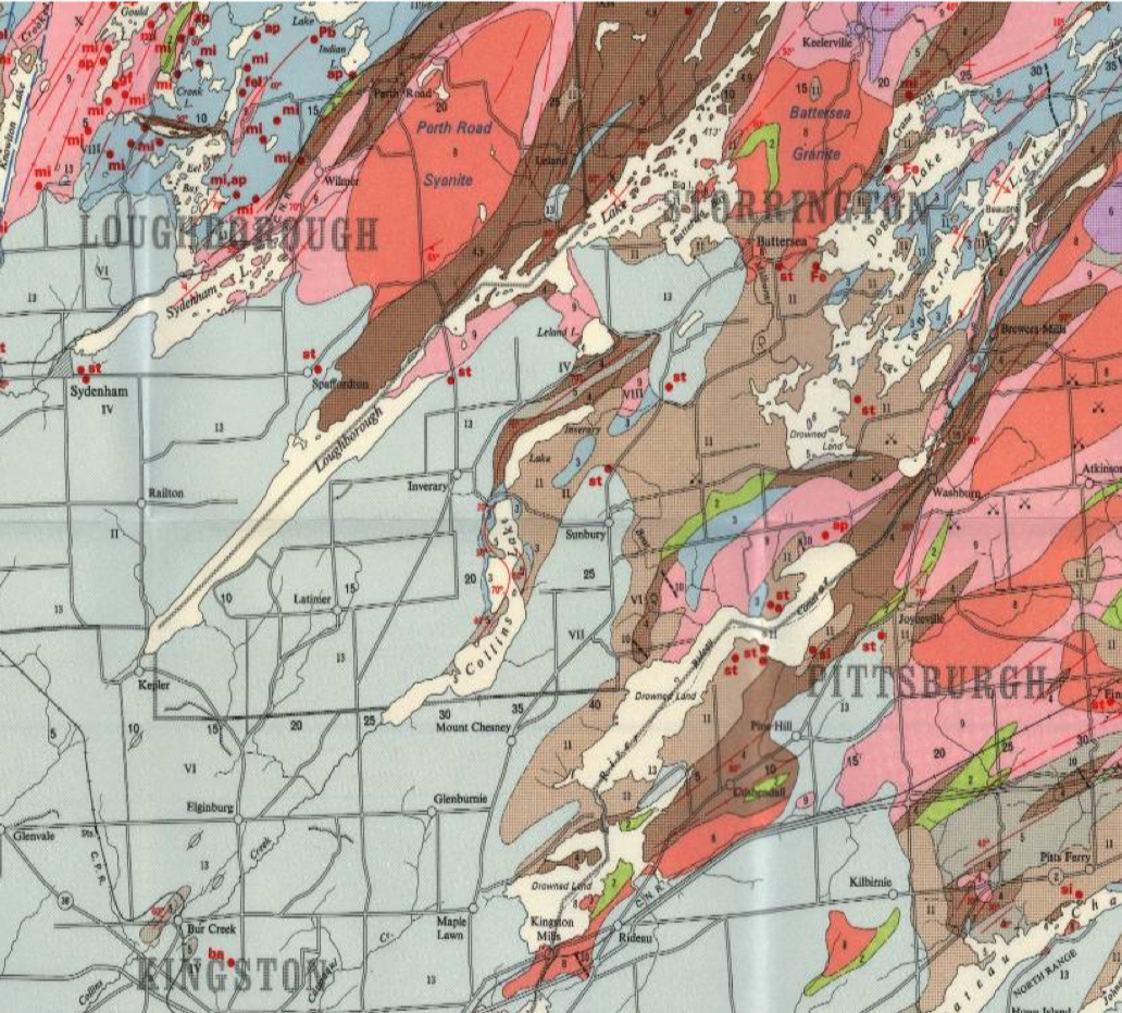
Figure 1. Geology at the edge of the Precambrian Shield (from D.F. Hewitt, 1964; Ontario Geological Survey Map 2054). Limestone is pale blue (or pale grey in black and white, map unit 13). The lake valley orientations are parallel to the local structural trend of folds and faults shown by the red lines.
To understand how the lake valleys may have formed we need to look at the big picture. The boundary between the limestone and Precambrian rocks in the Frontenac Arch is very irregular but from Holleford to the Rideau Canal, it is characterized by NE-pointing promontories underlain by limestone (Fig. 1). Between the headlands there are long narrow valleys. The valleys continue to the SW in fairly straight lines and commonly contain creeks (e.g., Collins Creek). Shaw and Gilbert (1990; Geology, 18, p.1169-1172) noted this relationship and suggested that the valleys were an interconnected network of channels that formed under the glacier and allowed meltwater to drain into the Lake Ontario Basin.
Although not stressed by these authors, ancient bedrock features likely played a part in valley development. Many of the folds, faults and planar fractures in the bedrock are oriented NE to SW (long-dashed red lines, Fig. 1). Not all rocks erode at the same rate and faults are typically persistent zones of weak rock. At least one such fault occupies the Loughborough Lake valley and was active after the formation of the limestone (the base of the limestone layers has dropped down 10 m across the lake and this is part of the reason Precambrian rock is exposed N of the lake and limestone is exposed on the S side). Powerful subglacial water flow exploited the paths of least resistance offered by preexisting zones of weakness. In other words, the location and orientation of recent lake valleys were controlled by features of the bedrock that formed hundreds of millions of years ago.

Figure 2: Fields near Perth Road Public School are strewn with large boulders (glacial erratics) on polished bedrock. There is only a thin layer of topsoil and most of the older glacial sediment (till) has been washed away by glacial flood events.
Gilbert and Shaw (1994; Canadian Journal of Earth Science, 31, p. 1630-37) confirmed and extended their hypothesis in a study of the shape of the bedrock surface in the SW part of Loughborough Lake using an echo-sounding survey. They found that the lake west of the bridge is in a narrow steep-sided valley up to 100 m deep characterized by large, long grooves, ridges and channels. The development of sub-glacial flow channels is known to occur under modern glaciers and enormous volumes of highly erosive, sediment-charged water can be released over time and intermittently at catastrophic rates. Loughborough Lake occupies one of the many flow channels that were cut across the boundary between limestone and the Shield by subglacial meltwater outburst floods. Other evidence for subglacial flooding in the area includes: large areas of no, or very thin, glacial sediment (till), isolated large boulders sitting on polished bedrock (Fig. 2) and smooth linear grooves cut into outcrops on many different size scales (Figs. 3 and 4).

Figure 3: A metre-sized groove cut into the side of an outcrop east of Buck Lake.

Figure 4: Small linear grooves on an outcrop surface south of Perth Road Village. Pebbles are aligned NESW in the bottom of a larger groove. Commonly, the grooves have few, if any, glacial striations (scratches) showing that they are relatively late glacial features.
You can learn about the subsurface geology of your property from water well records by the Ontario government, and clicking on your blue dot. Open the PDF file to see what the well driller found at different depths during drilling. Codes for rock types are: LMSN = limestone, SNDS = sandstone, and GRNT = any Precambrian basement rock except marble. In the Kingston area, "white LMSN" = marble.
Other free geological references may be downloaded from GEOSCAN:
- H.R. Wynne-Edwards Map 27-1962 for basement rock types
- B.A. Liberty Map 18-1970 for sedimentary rock types